Genesis uses Geographic Information System (GIS) technology as a digital ‘Where’ platform to manage, integrate, visualise and interpret the data and information that drives the energy industry.
Location data is a vital piece of intelligence which underpins our understanding of where things are, what they are and when events happen. Spatial data analysis can also help us to understand how things relate to one another, deriving new and valuable information.
Supported by our worldwide multi-disciplinary teams, our geospatial experts develop location-based solutions across the project lifecycle, including design, procurement, installation, operations and decommissioning; incorporating health, safety and environmental impacts and considerations.
Genesis has a strong background in the use of Esri’s ArcGIS software suite, including ArcMap, ArcGIS Pro, ArcGIS Enterprise and ArcGIS Online. We also work with complementary software (such as Geocortex) and Open Source (QGIS) where appropriate or required.
Core services of our ‘where’ platform include:
Data Management: the import and export of multiple different spatial datasets in tabular, CAD and GIS formats. We can work with PODS (Pipeline Open Data Standard), Seabed Survey Data Model (SSDM) and provide data cataloguing and metadata creation.
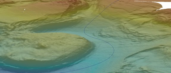
Data Visualisation, Analysis and Model Integration: we visualise data in 3D (including subsea lidar) to aid data exploration. Spatial analysis is performed to assist pipeline routing studies. We use the outputs of our environmental modelling (oil spill, underwater sound, sediment/cuttings and atmospheric dispersion) in our databases, maps and analyses to help our clients and industry regulators visualise, understand and manage the environmental impact of projects.
Mapping: we produce quality mapping outputs (static and interactive) for inclusion in project reports, websites or public displays.
WebGIS: we develop hosted WebGIS applications which provide remote, interactive access to custom GIS maps and data services over the Internet. These can be used to help facilitate project management as well as project planning and live operations. Examples include an in-house tool providing a map-based interface to environmental reports and engineering data; a WebGIS to support a subsea pipeline installation (with access to survey data, layout drawings and live vessel positions) and a decommissioning WebGIS with access to current and historic layout drawings and survey data to help inform the Comparative Assessment and Environmental Impact Assessment (EIA).